| The Cartooner's Weather Center, Lynden, Washington | |||
|---|---|---|---|
| The Weather Center is Temporarily Down ! Posted on Jan. 18 2005 | |||
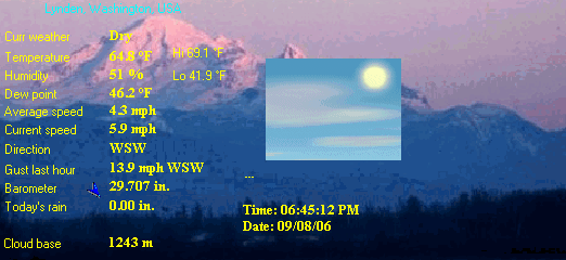
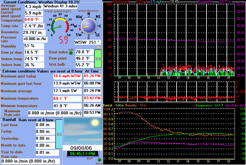
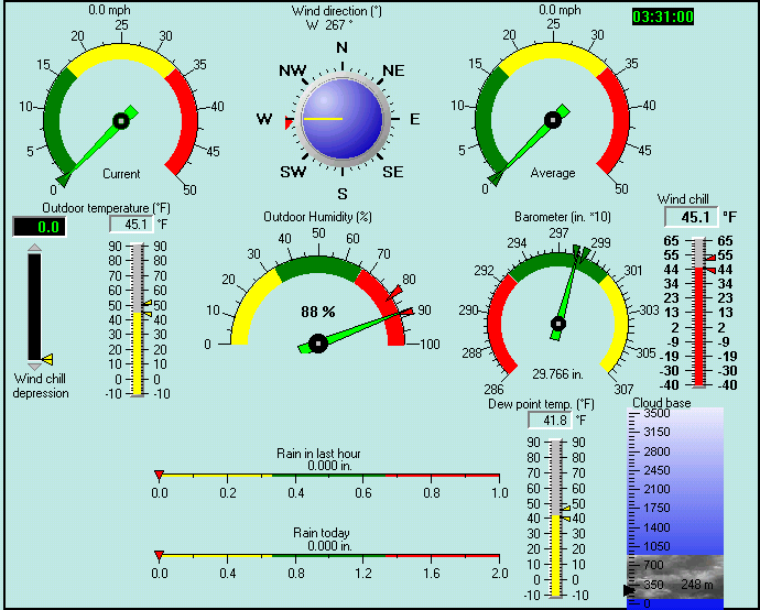
| Current Weather | Dry | Current Temperature | 35.4 °F (1.9 °C), Apparent temp 31.1 °F |
| Maximum Temperature (since 0 hour ) | 37.8 °F at: 03:14 AM | Minimum Temperature (since 0 hour ) | 34.0 °F at: 00:02 AM |
| Average windspeed (ten minute) | 4.8 mph | Wind Direction (ten minute) | ENE (68ş) |
| Windchill Temperature | 31.2 °F | Maximum Gust (last hour) | 11.5 mph at: 08:52 AM |
| Maximum Gust (since 0 hour ) | 18.5 mph at: 02:32 AM | Maximum 1 minute average (since 0 hour ) | 13.9 mph at: 02:34 AM |
| Rainfall (last hour) | 0.00 in. (0.0 mm) | Rainfall (since 0 hour ) | 0.00 in. (0.0 mm) |
| Rainfall This month | 0.31 in. (7.8 mm) | Rainfall To date this year | 40.88 in. (1038.4 mm) |
| Maximum rain per minute (last hour) | 0.00 in/min | Maximum rain per hour (last 6 hours) | 0.00 in/hour |
| Yesterdays rainfall | 0.00 in | DewPoint | 33.6 °F (Wet Bulb :34.7 °F ) |
| Humidity | 93 %, Humidex 31.9 °F | Barometer corrected to msl | 29.471 in. (998.0 hPa) |
| Pressure change | 0.00 in. (last hour) | Trend | STEADY |
| Pressure change (last 12 hours) | -0.12 in | Pressure change (last 6 hours) | -0.06 in |


Abbotsford, B. C., Canada (CYXX) 49-02N 122-22W 58M
Dec 29, 2004 - 10:00 AM EST / 2004.12.29 1500 UTC
Wind: from the SSW (210 degrees) at 2 MPH (2 KT):0
Visibility: 15 mile(s):0
Sky conditions: overcast
Weather: light rain showers
Temperature: 37 F (3 C)
Dew Point: 35 F (2 C)
Relative Humidity: 93%
Pressure (altimeter): 29.54 in. Hg (1000 hPa)
ob: CYXX 291500Z 21002KT 15SM -SHRA BKN030 OVC060 03/02 A2954 RMK SC6SC2 SLP006
cycle: 15

Use the RELOAD facility on your browser to retrieve the latest data.

